


2021 09 20Léa + Valmer

jmbilger
User
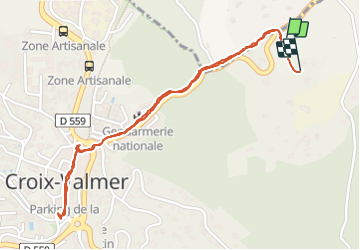

Length
2.6 km

Max alt
123 m

Uphill gradient
53 m
Km-Effort
3.3 km

Min alt
83 m

Downhill gradient
50 m
Boucle
Yes
Creation date :
2021-09-20 08:29:22.0
Updated on :
2021-09-20 09:28:08.412
38m
Difficulty : Easy

FREE GPS app for hiking
 SityTrail
IGN / Geographical institutes
SityTrail Plus
The world is yours!
About
Trail Walking of 2.6 km to be discovered at Provence-Alpes-Côte d'Azur, Var, La Croix-Valmer. This trail is proposed by jmbilger.
Positioning
Country:
France
Region :
Provence-Alpes-Côte d'Azur
Department/Province :
Var
Municipality :
La Croix-Valmer
Location:
Unknown
Start:(Dec)
Start:(UTM)
303236 ; 4787218 (32T) N.
Comments